Integrated report 2020


Supplementary descriptions are provided for projects and operations directly under Exxaro’s management control.
For projects and operations included in the Exxaro Mineral Resource and Mineral Reserve statement, but in which Exxaro does not have management control, the reader is referred to that company’s website for supplementary information (refer to foreword).
The Belfast mine is located some 10 kilometres (km) south-west of the town of Belfast in Mpumalanga, South Africa, on the far eastern edge of the Witbank coalfield. The coalfield extends about 190km east-west between the towns of Springs and Belfast and about 60km in a north-south direction between the towns of Middelburg and Ermelo. The mineral tenure areas of Umsimbithi Mining (Wonderfontein coal mine) and Universal Coal (Paardeplaats) are to the west and north of Belfast respectively.
The Belfast mine is adjacent to the N4 highway connecting Pretoria and Maputo and can be accessed from the N4 via two district roads, namely D1110 and D1770. The mine is also adjacent to the railway line to Maputo. Nearby loading facilities connect the railway line to Richards Bay. Currently mining is taking place from three open pits using doze-over, truck and shovel hybrid mining method. By August 2021, two more box-cuts will be opened up. Once fully developed, the mine will have 11 opencast pits. There are prospects for additional opencast pits and an underground mining section.
Thermal coal is beneficiated in a two-stage dense medium separation plant to produce for the export market: RB1/RB2, Middlings 4 800 kilocalories per kilogram (kcal/kg) net as received products. About 15% of RoM, mainly S2 is sent to a crush and stack plant operation to enhance production throughput at Belfast mine, producing an RB3 product for the export market. Existing Eskom power lines are on the property for electricity supply. The mining right has been approved and all environmental appeals have been favourably addressed for the declared Reserves. Coal Resources occur within most of the mining right whereas the Coal Reserve is limited to the southern mining right area aligned with the existing LoM plan. A project was initiated in 2019 to review the current exploitation strategy, including testing economic viability (macro-economic outlook) of the northern area considering open-cut and underground mining scenarios. This process lead to the implementation of a new exploitation strategy through which the schedule was optimised to align to the Exxaro early value extraction strategy over the remaining LoM.
Figure 9: Belfast mine
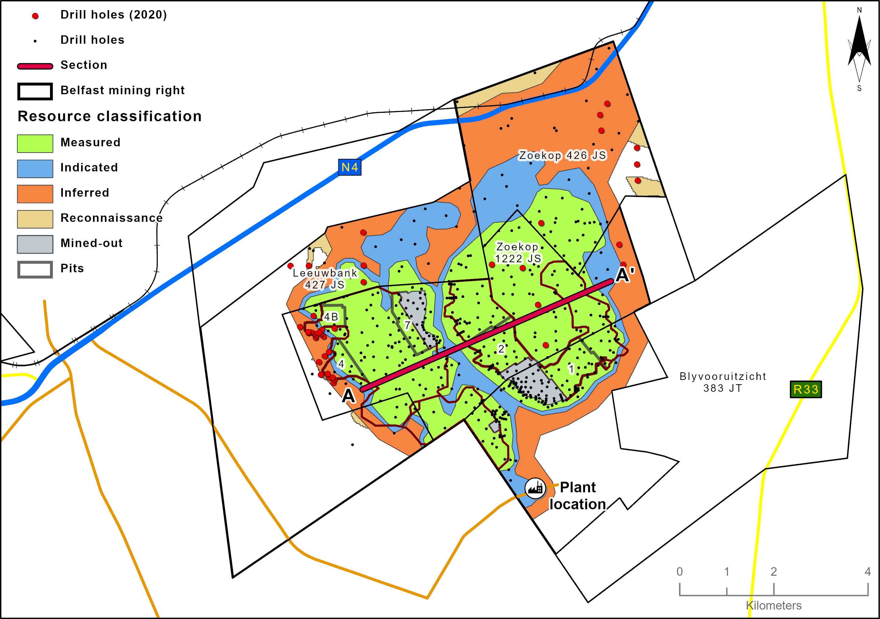
Belfast has an approved mining right that covers 7 198 hectares (ha). The geological model incorporates 616 boreholes. The geological database also includes 113 boreholes outside the mining right area.
Table 12: Belfast operation history
| Date range | Company | Material notes |
| 1967 | Fuel Research Institute of South Africa | 25 boreholes |
| 1969 | Trans-Natal Steenkoolkorporasie Beperk | 10 boreholes |
| 1975 to 1983 | Gold Fields Mining and Development | 43 boreholes |
| 2001 to 2003 | Eyesizwe | 155 boreholes |
| 2008 to 2009 | Exxaro | 153 boreholes to refine classification and potential box-cut positions |
| 2010 to 2019 | Exxaro | 133 boreholes to enable detailed box-cut designs and five-year mine plan infill drilling |
| 2019 to 2020 | Exxaro | 51 boreholes drilled to enable Pit 4 and Pit 4B box-cut delineation and detailed design as well as in the Belfast expansion area |
The Witbank coalfield has up to five coal seams in the middle Ecca Group sediments of the Karoo supergroup. The Karoo sequence in the area is represented by the Dwyka formation and the middle Ecca with little or no lower Ecca development. The middle Ecca sequence of coal horizons interbedded with sediments is highly truncated due to erosion with only very minor areas where the full sequence is developed. Locally, there are mainly three seams being targeted (S2, S3 and S4). The S5 was intersected in only two boreholes in the northern part of the project area. S2, the most prevalent seam, is consistently developed, except in areas where it has been eroded, and has an average thickness of 2.8m dipping gently to the south. Both S3 and S4 are sporadically developed due to erosion and both have an average thickness of 0.6m. Due to the proximity of the northern edge of the Witbank Basin, the primary control of the coal development is the current weathering surface. The deposit is therefore divided by a perennial stream into two Resource blocks under two distinct spurs in the surface topography. There is no indication of pertinent faulting from the borehole information but potential intrusions of dolerite dykes are outlined by regional airborne magnetics, indicating the possible occurrence of regional north-south trending dykes.
There are no known geological structures that may affect the geology or coal seam continuity.
The senior geologist supervises all borehole drilling and is responsible for logging and sampling in compliance with Exxaro’s logging and sampling standards, as well as standard operating procedures. Sampling of boreholes is only conducted after the stratigraphy has been correlated. All samples collected and bagged are registered in a sample sheet, which is also used as a dispatch sheet. The dispatch sheet is signed by the receiving laboratory personnel after ensuring that the number and sample ID on the dispatch sheet matches that of the actual samples to be analysed. Once the laboratory receives and signs the dispatch sheet, it is responsible for safekeeping and storage of that batch of samples.
All coal analysis was conducted at an accredited Bureau Veritas ISO/IEC 17025:2005 laboratory. Emphasis is placed on ensuring data integrity though rigorous procedures and supervision while processing. As part of the assurance and control process, audits are performed internally and externally. Bureau Veritas is South African National Accreditation System (SANAS)-accredited for analytical work and participates in monthly local and international round robins.
The Coal Resource classification methodology is fundamentally based on SANS 10320:2004 and considers borehole spacing, type of boreholes and structural complexity of the Resource. Alignment with SANS10320:2020 in is process. An update of the Resource and geological structural model is scheduled for 2021, incorporating new exploration information obtained during 2019/2020.
Figure 10: Belfast west-east cross-section

Table 13: Belfast Coal Resource reporting criteria
| Thickness cut-off (thickness and extraction height considerations) | Quality cut-offs (adb) | Geological loss |
| Opencast ≤0.5m Underground ≤1.2m* |
Ash >50% | 5% |
| * | Current proposed underground exploitation plan was used as a baseline for underground minimum thickness cut-off. |
Table 14: Belfast Coal Resource estimation criteria
Item |
Description |
|||
Database |
Borehole database | acQuire | ||
| Data datum | Cape LO29 | |||
| Number of boreholes used for Resource estimation | 309 of the 616 do have wash analysis | |||
| Validation | Conducted using queries in acQuire and Excel | |||
| Data compositing and weighting | acQuire | |||
Model |
Previous model date | 2012 | ||
| Last model update | 2018, scheduled for 2021 update | |||
| Geological modelling software | Geovia MinexTM | |||
| Estimation technique | Growth algorithm | |||
| Grid mesh size | 25m x 25m | |||
| Scan distance | 3 000m | |||
| Data boundary | 200m | |||
| Model build limits | Upper: limit of weathering and topography/collar Lower: basement/Dwyka |
|||
| Model outputs | Roof, floor and thickness grids generated for structure Raw quality grids |
|||
| Changes to modelling process | None |
Table 15: Belfast Coal Resource classification criteria
| Category | Type of boreholes | Borehole spacing | Structurally complex areas | Borehole/ha | ||||
Measured |
Cored boreholes with applicable coal qualities |
0m to 350m |
May be more conservative after consideration of RODA |
0.08 |
||||
Indicated |
Cored boreholes with applicable coal qualities |
350m to 500m |
May be more conservative after consideration of RODA |
0.04 |
||||
Inferred |
Cored boreholes with applicable coal qualities |
500m to 1 000m |
May be more conservative after consideration of RODA |
0.01 |
Table 16: Belfast Resource and Reserve statement
| Category | 2020 (Mt) |
2019 (Mt) |
Difference in tonnes (Mt) |
Difference (%) |
Reason for change |
| Measured | 71.3 | 74.6 | (3) | (4) | Mining depletion |
| Indicated | 19.9 | 20.1 | 0 | (1) | |
| Inferred | 34 | 34.1 | 0 | 0 | |
| Total Coal Resources (OC/UG) | 125.3 | 128.8 | (4) | (3) | Mining depletion |
| Proved | 40.2 | 42.2 | (2) | (5) | Primarily mining depletion |
| Probable | 2.1 | 1.4 | 1 | 50 | Change is due to introduction of new pit layout |
| Total Coal Reserves (OC) | 42.3 | 43.6 | (1) | (3) | Mining depletion was off-set by an increase due to pit layout changes |
Notes:
Table 17: Belfast RPEEE considerations>
| Item | Criteria | Criteria met | Comment | ||||
| Geological data | Data has been validated and signed off by competent person | Yes | Geological structures and depositional extent are considered as well as seam thickness <0.5m (OC) and <1.2m (UG), >50% ash content with coal qualities reported on an air-dry basis | ||||
| Geological model | Geological model has been considered and signed off | Yes | |||||
| Structural model | Structural model was considered and signed off | Yes | 2018 | ||||
| Mining | Mining assumptions considered and defined | Yes | Opencast and underground | ||||
| Assurance | Exxaro internal audits and external audit conducted | Yes | Internal review in 2019 and external audit by EY in 2020 | ||||
| Economic evaluation | Exploitation study with economic and mining assumptions, including geotechnical and geohydrological assumptions | Yes | Belfast exploitation strategy over mining right (2020) | ||||
| Environmental | Reasonable demonstration that environmental approvals can be obtained within the context of local, regional and national governmental legislation | Yes | Environmental management plan, integrated water use licence and National Environmental Management Act licences in place and compliant | ||||
| Tenure | Formal tenure must be demonstrated with reasonable demonstration that a mining right approval can be obtained within the context of local, regional and national governmental legislation | Yes | Mining and surface rights in place. Potential land acquisitions for expansions considered. Land access obtained for expansion drilling | ||||
| Infrastructure | Assumptions used should be reasonable and within known/assumed tolerances or have examples of precedence | Yes | Existing infrastructure adequate or can be upgraded with new required infrastructure under construction | ||||
| Market | A potential market for the product with a reasonable assumption that this market is sustainable | Yes | Primary product qualities suitable for A-grade export market and middlings suitable for domestic power generation |
Scheduling of the Reserve is determined using a mining scheduling application (Scheduler) from OCCS, which is the same software used to develop the LoM plan schedule. The geological 3D model used for the Resource statement is referred to as the Reserve geological 3D model.
The geological model is supplied to mining processes in the form of MinexTM grids. The grids are then imported into a reserving application (Reserver) from the same OCCS software. This application is used to validate the geological information received by checking the integrity of the geological structure and that quality and wash-table values are consistent, and to convert the geological 3D model into mineable block sizes.
Indicated Resources are generally converted to Probable Reserves and Measured Resources to Proved Reserves after consideration of all applicable modifying factors. If one or more of the modifying factors have not been fulfilled, Measured Resource is either not converted or the Measured Resource is converted but downgraded to Probable and the associated risk is clearly stated. Inferred Resources are not converted to Coal Reserves.
Some 0.5Mt of Inferred Resources are included in the LoM plan, representing 1.2% of the LoM plan, and are not considered material. The area with Inferred Resources, on the western edge of the pit, will only be reached towards the end of LoM.
Table 18: Belfast production figures
| Actual 2019 |
FC 2020 |
Actual 2020 |
FC 2021 |
FC 2022 |
|
| RoM (Mt) | 1.1 | 3.25 | 3.24 | 3.58 | 3.79 |
Table 19: Belfast modifying factors considered in converting Coal Resources to Coal Reserves
| Modifying factors | Value |
| Geological loss | 5% |
| Average thickness cut-off | S2 0.8m, S3 and S4 1.0m |
| Quality cut-offs | No quality cut-offs, economic cut-offs |
| Mining loss | 0.1m |
| Boundary pillar | 0 |
| Dilution | 0% |
| Contamination | 0.1m |
| Mining recovery efficiency | 100% (already accounted in mining loss) |
| Planned average slope angles | 90 degrees on hards and on softs |
| Practical plant yield | 88.30% |
| Strip ratio cut-off | Considered in the reserving process using the economic model to get mining boundaries |
| Environmentally sensitive areas | 100m |
| Legal | Applicable mining right considered |
| Social | Applicable communities considered |
| Geohydrological | Applicable surface and groundwater models considered |

Weathering impacting on coal seam continuity is a continuous risk, managed through strict grade control and infill drilling practices.
Proactive water management is vital to ensure effective mining production especially within the rainy season.
The Belfast expansion project currently under investigation will result in extending the LoM. This expansion will include the purchasing of a number of farms to the north of the current mining area. Access to these farms for exploration activities has been secured.
As part of the Exxaro market to resource excellence drive, Belfast Coal will be producing an RB2 product instead of an RB1 product for 2021. The product blend will continuously be reviewed to further optimise the market to resource excellence initiative.
A rigorous operational excellence process is also well entrenched at Belfast Coal where value chain optimisation is actively driven and progress tracked on a weekly basis to ensure the required optimisation of the mine production value chain is realised.